 |
| European Forests |
FORESTS IN EUROPE
Everyone is keen about how fantastic beach holidays are and the it isn’t difficult to go and to relax in the sun, with swimming in the sea and with watching the waves laping against the shores. On the other hand, while beaches are great and offer various relaxing facilities, forests offer some great places and locations to visit and discover too with wildlife, lush green, lots of walks, wildlife and a sense of peace by being close to nature. There are some spectacular "European Forests " that are worth to visit for anyone who enjoys this kind of scenery, either as a day out while you are at the particular destination, or as a place to stay in itself . Some of the famous European Forests are listed below:
The New Forest, England:
" that are worth to visit for anyone who enjoys this kind of scenery, either as a day out while you are at the particular destination, or as a place to stay in itself . Some of the famous European Forests are listed below:
The New Forest, England:
 |
| Map of New Forest |
With its most suitable weather condition, average rainfall 838 mm/year. The "New Forest" is a very big forest which covers an area of protected forest in England. It spans a large area and there are festivals and events which gives the opportunity to the city people to enjoy the nature. During the winter time there is a great Christmas display where the forest becomes a spectacular "Winter Wonderland".
The Black Forest, Germany:
 |
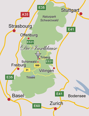
| Map of Schwarzwald |
It is named because of the thick conifers that blocks out the light in the forest, the black forest (Schwarz Wlad) is one of the most famous European forests and has a very "Magical Feel " especially during Christmas Time when the forest is covered with snow. Set in the mountains, and the birthplace of many stories and a wealth of food (such as the titular gateau and ham) this feels like the perfect setting for a fairy tale.
Belovezhskaya Pushcha, Belarus: Белове́жская пу́ща
 |
| Map of Belovezhskaya Pushcha |
A forest which is in between Belarus and Poland. On the Belarusian side the Biosphere Reserve occupies 1,771 km2 (684 sq mi); the core area covers 157 km2 (61 sq mi); the buffer zone 714 km2 (276 sq mi); and the transition zone 900 km2 (350 sq mi); the National Park and World Heritage Site comprises 876 km2 (338 sq mi). The Belavezhskaya Pushcha headquarters at Kamieniuki, Belarus  include laboratory facilities and a zoo where wisent, konik (a semi-wild horse), wild boar, elk, and other indigenous animals may be viewed in enclosures of their natural habitat. There is also a small museum, restaurant, snack bar and hotel facilities (built during the Soviet
  era and currently in a state of disrepair). Due to the lack of facilities and little tourist stream in the country, few foreign tourists visit the Belarusian Pushcha annually.
Pirin National Park, Bulgaria:
era and currently in a state of disrepair). Due to the lack of facilities and little tourist stream in the country, few foreign tourists visit the Belarusian Pushcha annually.
Pirin National Park, Bulgaria:
 |
| Map of Pirin NP |
Pirin 
is the second highest mountain range in Bulgaria after Rila (2,925 m) and the eighth highest in Europe.
If you like exploring some European forests at a higher altitude then Pirin National Park is the place for you discovering caves, waterfalls and a limestone landscape all in a great pine wood forest.
Ardennes, France :
 |
| Map of Ardennes |
Much of the Ardennes is covered in dense forests, with the mountains averaging around 350–500 m (1,148-1,640 ft) in height but rising to over 650 m (2,132 ft) in the boggy moors of the Hautes Fagnes (Hohes Venn) region of north-eastern Belgium. The region is typified by steep-sided valleys carved by swift-flowing rivers, the most prominent of which is the Meuse. Its most populous cities are Verviers in Belgium and Charleville-Mézières in France, both exceeding 50,000 inhabitants. The Ardennes is otherwise relatively sparsely populated, with few of the cities exceeding 10,000 inhabitants with a few exceptions like Eupen or Bastogne.